Enhancing Disaster Reviews and Improving the Policy Lifecycle
A Look Through the Lens of the GIC's High-Resolution Imagery
By Angela Brewster
Weather monitoring never takes a break with the Geospatial Insurance Consortium (GIC) and its Gray Sky team. Some disasters happen without warning, like tornadoes and wildfires. But when it’s hurricane season, the intensity grows even more as tracking builds over days to understand where, when, and just how massive a storm might hit a vulnerable community.
The Gray Sky program is the GIC’s flagship program, dedicated to collecting high-resolution aerial imagery following major natural disasters. It’s one reason the GIC has had such a long-standing partnership with the NICB, to help provide support to the insurance industry in times of crisis with detailed imagery showcasing the damage and destruction left after devastating storms.
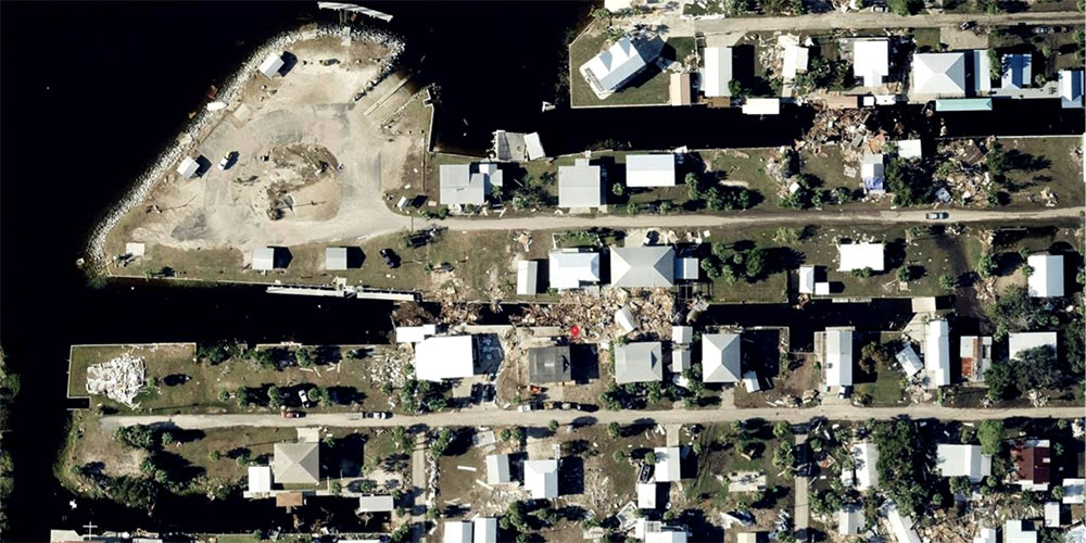
Florida is routinely ravaged by powerful hurricanes. In 2022, it was pummeled by Hurricane Ian, and then in 2023 pelted by Hurricane Idalia. Between both events, the GIC flew tens of thousands of square kilometers over multiple days, engaging multiple planes equipped with market-leading UltraCam camera sensors to collect both oblique and ortho imagery, and delivering massive amounts of aerial data through its online viewer platform, partner platforms, APIs, and ArcGIS within days.
This quick turnaround of information is made possible because of the GIC’s world-class processing pipeline that delivers high-resolution aerial imagery to GIC members and emergency managers as soon as possible. They know that following a critical event, time is the enemy as everyone is looking to understand what the actual impact is and how those whose lives have been turned upside down can begin the recovery and restoration process as quickly as possible.
A big benefit of using GIC imagery is the resolution of the aerial data. Ortho imagery is up to eight times better in resolution than satellite imagery; oblique imagery is up to 16 times better. This additional clarity helps elevate the review on a home or building as insurers can more accurately assess damage, or virtually tour a property from all sides with oblique views, reducing the need to send an adjuster out into the field.
Once initial imagery is published and GIC insurer members can quickly overlay their PIF information to assess which of their customers are in greatest need, the next phase of analytics is ready to roll out from the GIC.
Using historical, previously collected imagery from the impacted area, the GIC performs a damage assessment on all homes within an impact zone. This level of damage detection means insurers can see in seconds what exactly changed or was completely destroyed on a home by comparing it to the previous view.
Damage assessment uses machine learning to automatically generate these catastrophe analytics on Gray Sky imagery, and it’s effectively changing the way GIC members see and understand a storm’s impact.
How does this help solve an insurer’s post-CAT pain points? This level of analysis shortens the claims process by visually identifying the hardest hit homes or buildings in the impact zone. Members can then compare their PIFs against this data to pinpoint those customers in greatest need and proactively begin the claims process.
GIC imagery provides multiple opportunities for insurers to improve their workflows across the entire policy lifecycle, but especially following a major catastrophic event. With the GIC’s historical imagery and Gray Sky collections, members can:
- Complete a remote assessment of a property without needing to set foot on the ground
- Support a more accurate, reliable claims process using trusted ground truth
- Use oblique imagery to virtually tour and inspect a property to validate a claim and weed out fraud
- Evaluate the damage to a given area to improve underwriting for future policies
- Enhance risk analysis by updating catastrophe models following a major storm.
Angela Brewster is a seasoned marketing and content creator and is currently serving as the Content & Brand Marketing Manager for Vexcel, the operations partner for the GIC.
Anyone with information concerning insurance fraud or vehicle theft can report it by calling toll-free 800.TEL.NICB (800.835.6422) or submitting a form on our website.
About the National Insurance Crime Bureau: Headquartered in Oak Brook, Ill., the NICB is the nation's leading not-for-profit organization exclusively dedicated to combatting and preventing insurance crime through Intelligence, Analytics, and Operations; Education and Crime Prevention; and Strategy, Policy, and Advocacy. The NICB is supported by more than 1,200 property-casualty insurers, self-insureds, rental car, vehicle finance, and auto auctions. To learn more, visit www.nicb.org.